The Adventures of a Science Teacher

Tag: hiking

Saving the Best for Last

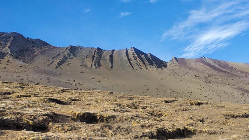
Of all of my excursions I was looking forward to hiking Vinicunca, or Rainbow Mountain, the most. This is a fairly new tourist destination in Peru because up until fairly recently the top of the mountain was covered by glaciers. The glaciers have since melted which led to the discovery of the rocks that give it its name Rainbow Mountain.

Definitely the coolest alpacas you will ever meet!

This would be one of several very early mornings in a span of a few days. Our tour group would leave at 3:00 a.m. to beat the crowds which turned out to be a great decision. We were the second tour there and by the time I was descending the mountain there was pretty much a single file line of people trying to make their way up.

Tilted layers of rock. The more resistant layers stick out while the less resistant layers wear away.

The climb was not easy. It was about a four mile round-trip hike that would take me over 17,000 feet of elevation. Given the fact that it was Winter and I was so high it was by far the coldest morning of the trip. There was ice and frost on the ground and I had to break out the hat and gloves. Most people opted to ride horses up the majority of the mountain but I wanted to hike it. As I approached the top I would take a step or two, breathe heavily for a minute or so, and then take a few more steps.

It was definitely worth it. These colors were not edited like in the pictures you see online.

The ridge of rainbow mountain is made up of layers of rock of different types that have been tilted over time. I’m not sure if I’m 100% correct but I will act confident so people will believe me. The reds are due to iron oxides present in the rock, the greens are from the mineral chlorite, yellows are due to iron sulfides in the rock, and the purplish colors come from goethite. As a rock nerd it was difficult to take my eyes away from the amazing views even as my lungs burned from the cold, dry, lack of air.

Glacier on a nearby mountain
The u-shaped valley is evidence that this area was once covered by a valley glacier. At the base of the valley an outwash plain was evident.

All good things must come to an end. The tour guides herded us up and it was time to descend the mountain. This would be much easier than the ascent although as I approached the parking lot I started to feel a little light headed and I started to develop a headache. Hours at very high elevation (the highest I had previously hiked was 13,000 feet) and very little water probably played a role. Once back in the bus we would stop for lunch which would clear up my headache. That night I would fly from Cusco to Lima so that I could catch an early morning flight home. I paid for a hotel room that I would only use for about 2.5 hours between getting in after midnight and needing to leave the hotel at 3:00 a.m. the next morning. It was a great trip but it was very good to get home.

Come visit my friends and I at Rainbow Mountain!

Of Course I Went There

Machu Picchu. When most people think about Peru visions of Machu Picchu form in their head. I’m sure eventually I would have gotten the question about whether or not I visited so I figured I would get that out of the way up front. I will not be talking about the frustrations with the tour company I was booked through and all the problems I had including getting off the train in Aguas Calientes with no idea of what I was supposed to do. Let’s keep this positive!

Here is a sneak peak of what it looked like. Yes, it rained. The only day of rain in three and a half weeks.

My tour of this majestic set of ruins would not be until the second day of my hike. On the first day we would stop at several ruins in the Sacred Valley. One of these ruins was Pisac. Like so much of the Incan ruins they were built on a mountain. It is believed that this complex was built as a residence, an astronomical observatory, and for religious purposes. My memory isn’t what it used to be and I went here a month and a half ago so I don’t remember much. Here is a picture!

All of the holes in this cliff were burial tombs. I would not want to be the one to carry a body up that steep slope!
One of the buildings at Pisac. The slanted walls make it earthquake proof.

After visiting these ruins we went to lunch. It was the only disappointing meal I had in my entire 25 day adventure. That comes out to one bad meal out of about 142 meals that I ate so I am not complaining. Next we went to another set of ruins where we climbed a lot of stairs, tried to look at some temple, and then quickly went back down the stairs because some of us had to catch the train. It was a beautiful train ride to Aguas Calientes, a town at the base of Machu Picchu. We would arrive after dark and I will skip the rest.

I learned how to tell the difference between Llamas and Alpacas. These are llamas.

The next morning a small group of us started the hike to the main gate of Machu Picchu. We started off well before sunrise so headlamps were a necessity. My previous 3 weeks was spent in a desert and I was not ready to hike in the rainforest. The humidity was 100% and it was warm. Shortly after beginning the ascent I was completely drenched in sweat. The climb was not that steep nor was it long but I definitely struggled. Upon reaching the gate I changed into a dry shirt which was then soaked through by the fog and the rain. For one glorious minute I was wearing a dry shirt though.

How did this rabbit get into this window? I have so many questions!

After a short walk we arrived at **The Spot**. It might have a name but this is the spot that everyone goes to for the iconic picture of Machu Picchu. It looked pretty grey to me. We hung out for an hour or so to wait for the weather to break. During this time we learned about the history of the the complex. It is much more impressive than I could have ever imagined. How did someone see these steep cliffs and then say to themselves, I want to build up there? For defense and security I totally get it but it must have been quite the endeavor especially considering it is built out of granite, a very hard rock.

From out of the fog came these ruins. Our patience was rewarded.

Eventually we had our fill of looking down into a large collection of the ruins and it was time to walk through them. The fog continued to lift and we would eventually see some blue skies. Now for more pictures!

I believe that this used to be a school or some sort of academy.
Some sort of astronomical observatory. The sun comes through specific windows and lands on specific parts of the rock on certain days of the year. In other words, this was somewhat of an ancient calendar.
Some more ruins
Temple of the Condor. In the center on the bottom is the head and you can see the wings going out on either side of it. The large tan and black rocks that the temple walls are built around.

Several hours later it was time to leave. We built the crowds, partially due to the poor weather, and we made our way to the buses. We didn’t see the point of walking the trail down especially considering it reeks of urine. Yea, you probably didn’t want to know that. What I found interesting is that the bus tickets are the only thing I saw in all of Peru that is in US dollars. I was not expecting that so I didn’t have any on me. Once back in town I wandered for a couple hours and was amazed at how long the line was for people to take a bus up the mountain. Some of these people would probably have to stand in line for hours. After lunch it was time to board my train and I headed back to Cusco.

This fountain in Cusco was a gift to the city from NYC. Apparently there is a similar one somewhere in the city. Someday I will have to go look for it.

Will I Make It Out of the Canyon?

Day two in the Canyon saw a much later start than the previous day. As mentioned in the previous post, there are several reasons why I was glad that I chose to do this hike in three days instead of two days. It was nice to be able to relax within the cabin and we enjoyed some really good food our first day in the cabin. The second reason I am glad that we did the three day hike is that we got to walk through two towns that the other hikers did not get to see and we were able to learn more history about the people in the canyon. After a fairly short walk we arrived in Cosñirhua. Primary students in San de Chuccho would have to walk to Cosñirhua to attend school. There are very few kids in this age group though as the school would only have eight students and one teacher.

Cosñirhua. You can see the school to the left of the image with the courtyard covered with the green tarp. It didn’t take us long to walk through this town.

There is a gold mine on the opposite side of this mountain and they have invested in these towns. They are the reasons they have roads and they are building an aqueduct to help provide water to the people that live here. There is only one secondary school in this valley and while there used to be a school bus to take students to this town (towards the top of the valley) it is broken so students have to walk up to 90 minutes to get to school. Not sure what is happening with the bus but the gold mining company bought it. Hopefully they plan on fixing it.

Aqueduct cut through the mountain. Earthquakes will often damage infrastructure like this.

The next town we would walk through would be Malata. This primary school has 14 students currently attending it. We walked past a tiny little clinic that is the only clinic if people get sick in any of these towns. Down the road a little further is a private clinic (much nicer) that is for the gold miners. Apparently in emergencies they do help out the people that live there.

Entering Malata

After passing through Malata we would drop back down to the bottom of the valley to cross the Colca River again. Once we crossed the river we would climb back up a little bit and enter Sangalle, an oasis at the bottom of this valley. There are no roads to this town and the only way to get in or out is by walking. Mules carry goods in and out of the bottom of this valley.

Sangalle. The trail out of the canyon can be seen on the left.

The third reason that I was glad that I did the three day hike is that I got into Sangalle around noon. This meant I got to enjoy the swimming pool during the heat of the day. Since we were near the bottom of the canyon, the sun set behind the canyon walls around 3:30 p.m. and temperatures dropped quickly. It is winter in Peru. People that did the two day hike arrived at Sangalle between 4 p.m. and 7 p.m. and they could not enjoy the pool as much as we did. Some of them did jump in but they found it really cold.

The pool in Sangalle

It was an early night as the next morning would be tough. We would be hitting the trail by 4:4o a.m. to hike to the top of the canyon. Our goal was to reach the top before the sun rose and then we would get to have breakfast. The climb was steep but we made good time. We hiked over a mile in the first hour. Things started to slow a little at that point though. What made it tough was how dry it is. You don’t realize how much dust is kicked up hiking in this area until you are hiking by headlamp. As the second hour ticked by fatigue was starting to set in. It looked like the top was approaching but I know how misleading false summits can be. It turns out that this wasn’t a false summit and I was almost to the top. With about 15 minutes of hiking remaining the sun started to rise. When I reached the top there was this tremendous sense of accomplishment.

The hike out of the canyon. The last half of a mile to town was flat. That means we climbed about 3500 feet in just under 3 miles.
I did not drink any chicha prior to starting this hike. This is what the trail was like!

After reaching the top we walked another half a mile to town, had breakfast and left. Not too long after leaving we stopped at some natural hot springs to soak our tired/sore legs and it did feel good. On our way back to Arequipa we stopped at a viewpoint that was over 16,000 feet high and saw several volcanoes. We stopped once more so people could use the restrooms but I was fixated on the volcanoes as well as the hoodoos that I saw. Eventually we made it back to Arequipa and I prepared to move on to my next destination early the next morning.

Smoking volcano!
Peruvian hoodoos!

A Hike? To the Bottom of the Second Deepest Canyon on Earth? Sure!

These are the things that I get myself into when I don’t get much sleep. Then again, I probably would have still done it anyways! I do want to disclose that we didn’t start from the canyon’s highest point nor did we go into the deepest part of the canyon but it was still about 4,000 feet of difference from the highest point to the lowest point. This adventure would start from Peru’s 2nd most populated city, Arequipa. This city is beautiful with buildings constructed of volcanic rock. It is also surrounded by volcanoes!

You can see some snow-capped volcanoes in the background

For my hike of the Colca Canyon I had the choice of doing it in two days or three days. I’d previously spent the past two weeks in cities and I was looking for some relaxation so I opted for the three day hike. Apparently this is not very common and there was only one other person. Everyone else does it in two days and we were both glad we chose three days for reasons which will be explained later.

Andean Condors

Like so many of my adventures, we got an early start. I had to be ready to go by 3 a.m. After two hours of driving we stopped at an overlook where Andean Condors like to ride the thermals. These condors are the heaviest flying birds and can have wingspans that reach 11 feet! They can go months between meals and can go hours circling the skies without flapping their wings. The Andean condor was considered holy by the Incas.

A juvenile condor dropped by for a visit

After a little more driving we arrived to the trailhead for the start of our hike. We were on the southern rim of the canyon which meant that the walls of the canyon were facing the north. This is weird to say but during the day the sun is in the northern part of the sky. While it is indeed winter, we are at a fairly low latitude so the sunlight would be fairly strong. When paired with the high altitude, solar intensity would affect me much more than the elevation would.

A map showing average solar intensity for July. The red indicates high intensity. The red line was our the approximate path we took over the three days.
You can see three towns we would walk through in this image. We would spend the night at the town on the far right. Beneath the towns are terraces created by the Incas and pre-Incan cultures to reduce erosion and for agriculture.
Looking down on Sangalle, an oasis at the bottom of the canyon. We would come in from the right, spend the second night here, and hike out towards the left.

After a short hike along the rim we began our downward journey to the bottom. The sides were steep and the trails were just several miles worth of switchbacks. One misstep and you would find yourself falling uncontrollably towards the bottom of the canyon. This wasn’t too much of a concern at first but after hours of being out in the sun and feeling the effects of heat exhaustion I had to be extra careful with where I stepped.

The trail before the switchbacks began. The slope it crosses is incredibly steep!

As we descended, sheer walls of columnar basalt towered over us. It was intimidating and unnerving to know that an earthquake could occur at any time that could bring these walls down on top of us and we would have nowhere to go. Fortunately there were no earthquakes and I could admire all the geologic wonders that were there.

Columnar basalt

Eventually we did make it to the bottom of the canyon. After crossing a bridge across the Colca River it was time to start ascending up the other side a little bit. By this time the heat was really getting to me and I struggled more than I should have. It would not be too much longer until we got to the small town, San Juan de Chuccho, where we would have a lunch (made over a fire) and spend the night. Avocados are grown in this valley and it was served with every meal. The food we had while staying here was excellent and the woman was very nice. It is impressive because there is no road nor is there any electricity. After lunch, the people hiking the canyon kept going another 3 miles while I got to relax in the canyon and take in the views.

In the foreground you can see the building I spent the night in. In the background you can see the trail zig-zagging down the slope.

It took me a few hours of hydrating and resting to start to feel like myself again. Agnes would have been disappointed as I was not able to finish my lunch. By dinner I had my appetite back and was back to finishing my meals. Stay tuned for part two of the Colca Canyon trek!

Powered by WordPress & Theme by Anders Norén