The Adventures of a Science Teacher

Tag: teaching Page 1 of 3

What Impacts Will Climate Change Have on the Daily Lives of Peruvians?

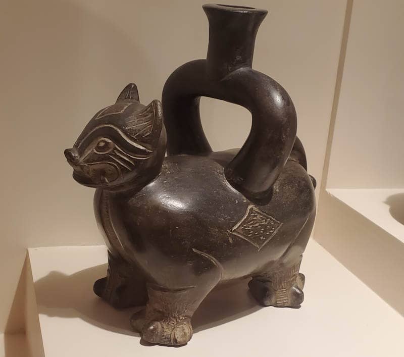
Climate change is a major concern that will affect us all. Through workshops, presentations, and reading science articles I have learned quite a bit about the impacts that climate change may have on New York State and the NYC watershed in which I live. As I prepared for my field experience I wanted to learn how it will impact life in Peru. To begin our journey we will go back in time several millenia to look at the climate in Pre-Incan Peru. Much of this information came from exhibits held within Museo Larco. If you are ever in Peru I highly recommend visiting it.

One of countless artifacts contained within the museum.

Agriculture was a major component of the societies of ancient Peru as seen by the vast quantities of terraces. Their main concern was that the cycles of nature would go unchanged. They understood the importance of these cycles and even created observatories to mark significant events like seasons. There were three conditions that were of great importance:

  • That the climate was favorable and water arrived at the right time and in sufficient quantity.
  • That the land was fertile
  • That people worked in an organized manner.

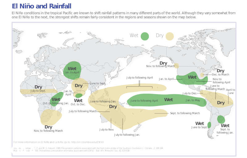
The end of the Moche culture may have been partially the result of a change in one of these cycles. El Niño is a natural climate pattern that is caused by a weakening of the trade winds over the Pacific Ocean affecting the weather globally. Around 600 CE a very strong El Niño occurred flooding irrigation systems and reducing the amount of fish off the coast. This led to the people losing faith in their leaders who are considered to be representatives to the gods.

Image from NOAA showing how El Niño affects rainfall. Peru, which is normally dry, receives more rain than normal.

Ironically, it is due to El Niño that researchers have so many artifacts to study. The number of Incan artifacts is relatively low because the Spanish destroyed most of them when they conquered the Incas. Older artifacts were buried and thus preserved. Approximately, every 18 to 25 years Peru’s northern coast sees torrential rains as a result of El Niño which causes flooding. The receding floodwaters leave a layer of mud that marked the period in which the rain occurred. Layers of wind-blown sand build up between the layers of flood-derived sediment. The study of this stratigraphy allows archaeologists to calculate the ages of the artifacts.

Terraces along the Colca River

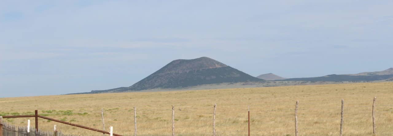
It is clear that climate played a major role in the lives of the ancient Peruvians but that doesn’t quite address my question. While hiking through the Colca Canyon (see earlier post) I learned first-hand how a changing climate has affected the life of these ancient peoples. In Pre-Incan times, the terraces were built higher up on the mountain because there were ten rainy months during the year so the river was higher. The Incans built terraces lower on the canyon walls because they saw six or seven rainy months. Now it rains only two or three months out of the year and the river is quite low. With receding glaciers, water access in this canyon will be impacted. These climate changes occurred at a much slower rate than we are seeing today which is alarming.

Parts of Lima have buildings made of mud bricks like seen at these ruins. This is fine when you live in a location that receives no rain but when the rains do come your buildings will disintegrate.

Moving to present day, I tried to ask a variety of stakeholders what impacts they were seeing related to climate change today. It was hard to get a clear answer at times because from what I was told, the terms weather and climate are often used interchangeably so much was lost in translation. As mentioned earlier, Lima receives only something like five centimeters of rain a year. This is not enough to provide for a city of over eleven million people. The city receives its water from three rivers that flow from the Andes to the Ocean. As the temperatures warm due to a changing climate, the glaciers are receding which is reducing the water in the rivers. Glaciers melt slowly over time providing water gradually to the rivers. Without glaciers there might be times with little to no runoff.

Growing grass and flowers (no flowers in this particular median) does not seem like an efficient use of a limited resource like water.

Heavy rain events are very rare in Lima but their frequency is increasing. They used to occur every 40 to 50 years but now that is down to 30 to 40 years. In certain parts of the city they used mud bricks to build their buildings which totally disintegrate in a wet climate. Heavy rains lead to erosion and can impact the turbidity of the water in the rivers. With no reservoirs this excess water is just lost to sea. Changing ocean temperatures may reduce the productivity of the ocean as well. Warmer temperatures lead to less plankton which leads to less marine life. Fishing, the life-blood of many Peruvians, is at risk.

I have a lot further to go in my understanding of how climate change will affect life in Peru but I have a foundation to build upon. I’m hoping that over time I can find a group of Peruvian students to partner my students with so we could learn from each other and work on developing local solutions that we could each implement within our respective communities. Maybe someday we will be like the ancient Peruvians and work towards protecting the natural cycles.

Some Islands Do Float!

The morning after I completed my Colca Canyon trek it was off to Puno. The day started off a little rough as the bus to pick me up was late and I was concerned that it had forgotten me. Then about an hour from Puno the bus had mechanical issues and we lost about 45 minutes as the driver tried to figure out what was wrong. Fortunately for those of us going to Puno, we were close to a small town where we transferred to a van for the remainder of our trip. The roads in Puno are way too narrow for something like a bus. The rest of the passengers would wait in town while the mechanic tried to figure out what was wrong with their bus. Then they had a long drive through a remote part of Peru to get to Cusco.

Puno Cathedral, an 18th century baroque-style church

My afternoon in Puno would be relaxing as I needed a break and the elevation was a little under 13,000 feet. Just going up stairs was enough to get me breathing hard. The next morning I left for a two-day trip on Lake Titicaca, the highest navigable lake in the world! Not too long after boarding the boat we arrived at the Uros Islands. These islands are floating islands created by the Uros people out of totora reed. This reed needs to be replenished frequently to reduce the possibility of fire and to keep the islands stable.

This is the island we stopped at. Each family group creates their own island.

We stopped at one of the islands and got off our boat. One of the passengers immediately lit up a cigarette and quickly was told to put it out. The reed that makes up these islands is like straw but thicker. Fire and straw do not go together. On this island we received a tour and saw a presentation about how the islands are made. On these islands the people speak Aymara but our guide was able to translate. Initially the Uros moved to Lake Titicaca to avoid the Incas who were taking over this part of South America. The islands were a form of defense that could be moved to evade their enemies. The first to move out on the lake lived in boats but then they created these floating islands. Now people live on them so they don’t have to pay taxes.

A model of the creation of a floating island.

Once our tour was over we got onto a boat made out of reed and rode it to another island. After purchasing some delicious bread made of quinoa it was back on our tour boat and off to Amantani.

The reed boat we rode
The floating school at Uros. This is a primary school only as most kids are pregnant by the time they are 16.

I would be staying on the island of Amantani with a native Quechua family. Upon stepping onto the island we were broken up into small groups and were introduced to our host family. The Amantani people speak Quechua but the younger generation has learned Spanish in school so it was easier to communicate. It was a struggle to walk uphill to our house as we were at just under 13,000 feet of elevation. I had not gotten used to the lack of oxygen yet. At our house we were shown our rooms for the night, we had a freshly cooked lunch (delicious!), and then we gathered at the central square for a short hike.

The house I stayed at. The whole family was wonderful!

We would be climbing towards the top of the island to visit one or both of the temples on the island. Once again, climbing was a lot more difficult than I would have thought. It wasn’t steep but the lack of oxygen definitely was felt. After a while I made it up to the temple devoted to Pachatata (Father Earth). From there you could see villages around the perimeter of the island.

Pachatata from Pachamama

When I had caught my breath I descended this hill and then begin the ascent to the temple devoted to Pachamama (Mother Earth). This hill was higher and it offered great views of the sunset. By the time I started to descend the temperatures dropped significantly.

Pachamama temple
The setting sun over the lake

When we returned to our house we had a quick dinner and even though we were all exhausted it was then time to prepare for the nights event. There would be a dance in town with everyone in the village invited. To enter you need to wear traditional attire and fortunately for me it was pretty basic for guys. It was just a poncho and a chullo (Andean style hat). The women had to wear quite a bit more. Nobody stayed very long and upon returning to our house we were asleep in no time.

The next morning we returned to the shore for a quick excursion to another island Taquile. While here we climbed up to the top, saw some native dances, had lunch, learned how they make their native shampoo, and then descended the other side and got back onto the boat.

Making natural shampoo

Comparing Amantani and Taquile

Even though the two islands are close to each other they are quite different. On Amantani all men wear the same clothes and all women wear the same clothes. Once they get married, the women always have knitting needles in their hands. The men sit around and don’t do very much. On Taquile, the men and women wear different clothing depending on their age and their marital status. Once the men reach a certain age they wear a different hat. Once they get married they wear yet another hat and a bag where they store their coca leaves. As part of the wedding ceremony, the men weave some sort of blanket that the women will use to carry things as well as their baby. The women make a chumpi (a thick, cummerbund-like waistband) for their husband. The inner layer is made of her hair. The guide didn’t get into the different clothing the women wear. When they get married, the men are always knitting while the women sit around and don’t do much.

Will I Make It Out of the Canyon?

Day two in the Canyon saw a much later start than the previous day. As mentioned in the previous post, there are several reasons why I was glad that I chose to do this hike in three days instead of two days. It was nice to be able to relax within the cabin and we enjoyed some really good food our first day in the cabin. The second reason I am glad that we did the three day hike is that we got to walk through two towns that the other hikers did not get to see and we were able to learn more history about the people in the canyon. After a fairly short walk we arrived in Cosñirhua. Primary students in San de Chuccho would have to walk to Cosñirhua to attend school. There are very few kids in this age group though as the school would only have eight students and one teacher.

Cosñirhua. You can see the school to the left of the image with the courtyard covered with the green tarp. It didn’t take us long to walk through this town.

There is a gold mine on the opposite side of this mountain and they have invested in these towns. They are the reasons they have roads and they are building an aqueduct to help provide water to the people that live here. There is only one secondary school in this valley and while there used to be a school bus to take students to this town (towards the top of the valley) it is broken so students have to walk up to 90 minutes to get to school. Not sure what is happening with the bus but the gold mining company bought it. Hopefully they plan on fixing it.

Aqueduct cut through the mountain. Earthquakes will often damage infrastructure like this.

The next town we would walk through would be Malata. This primary school has 14 students currently attending it. We walked past a tiny little clinic that is the only clinic if people get sick in any of these towns. Down the road a little further is a private clinic (much nicer) that is for the gold miners. Apparently in emergencies they do help out the people that live there.

Entering Malata

After passing through Malata we would drop back down to the bottom of the valley to cross the Colca River again. Once we crossed the river we would climb back up a little bit and enter Sangalle, an oasis at the bottom of this valley. There are no roads to this town and the only way to get in or out is by walking. Mules carry goods in and out of the bottom of this valley.

Sangalle. The trail out of the canyon can be seen on the left.

The third reason that I was glad that I did the three day hike is that I got into Sangalle around noon. This meant I got to enjoy the swimming pool during the heat of the day. Since we were near the bottom of the canyon, the sun set behind the canyon walls around 3:30 p.m. and temperatures dropped quickly. It is winter in Peru. People that did the two day hike arrived at Sangalle between 4 p.m. and 7 p.m. and they could not enjoy the pool as much as we did. Some of them did jump in but they found it really cold.

The pool in Sangalle

It was an early night as the next morning would be tough. We would be hitting the trail by 4:4o a.m. to hike to the top of the canyon. Our goal was to reach the top before the sun rose and then we would get to have breakfast. The climb was steep but we made good time. We hiked over a mile in the first hour. Things started to slow a little at that point though. What made it tough was how dry it is. You don’t realize how much dust is kicked up hiking in this area until you are hiking by headlamp. As the second hour ticked by fatigue was starting to set in. It looked like the top was approaching but I know how misleading false summits can be. It turns out that this wasn’t a false summit and I was almost to the top. With about 15 minutes of hiking remaining the sun started to rise. When I reached the top there was this tremendous sense of accomplishment.

The hike out of the canyon. The last half of a mile to town was flat. That means we climbed about 3500 feet in just under 3 miles.
I did not drink any chicha prior to starting this hike. This is what the trail was like!

After reaching the top we walked another half a mile to town, had breakfast and left. Not too long after leaving we stopped at some natural hot springs to soak our tired/sore legs and it did feel good. On our way back to Arequipa we stopped at a viewpoint that was over 16,000 feet high and saw several volcanoes. We stopped once more so people could use the restrooms but I was fixated on the volcanoes as well as the hoodoos that I saw. Eventually we made it back to Arequipa and I prepared to move on to my next destination early the next morning.

Smoking volcano!
Peruvian hoodoos!

A Hike? To the Bottom of the Second Deepest Canyon on Earth? Sure!

These are the things that I get myself into when I don’t get much sleep. Then again, I probably would have still done it anyways! I do want to disclose that we didn’t start from the canyon’s highest point nor did we go into the deepest part of the canyon but it was still about 4,000 feet of difference from the highest point to the lowest point. This adventure would start from Peru’s 2nd most populated city, Arequipa. This city is beautiful with buildings constructed of volcanic rock. It is also surrounded by volcanoes!

You can see some snow-capped volcanoes in the background

For my hike of the Colca Canyon I had the choice of doing it in two days or three days. I’d previously spent the past two weeks in cities and I was looking for some relaxation so I opted for the three day hike. Apparently this is not very common and there was only one other person. Everyone else does it in two days and we were both glad we chose three days for reasons which will be explained later.

Andean Condors

Like so many of my adventures, we got an early start. I had to be ready to go by 3 a.m. After two hours of driving we stopped at an overlook where Andean Condors like to ride the thermals. These condors are the heaviest flying birds and can have wingspans that reach 11 feet! They can go months between meals and can go hours circling the skies without flapping their wings. The Andean condor was considered holy by the Incas.

A juvenile condor dropped by for a visit

After a little more driving we arrived to the trailhead for the start of our hike. We were on the southern rim of the canyon which meant that the walls of the canyon were facing the north. This is weird to say but during the day the sun is in the northern part of the sky. While it is indeed winter, we are at a fairly low latitude so the sunlight would be fairly strong. When paired with the high altitude, solar intensity would affect me much more than the elevation would.

A map showing average solar intensity for July. The red indicates high intensity. The red line was our the approximate path we took over the three days.
You can see three towns we would walk through in this image. We would spend the night at the town on the far right. Beneath the towns are terraces created by the Incas and pre-Incan cultures to reduce erosion and for agriculture.
Looking down on Sangalle, an oasis at the bottom of the canyon. We would come in from the right, spend the second night here, and hike out towards the left.

After a short hike along the rim we began our downward journey to the bottom. The sides were steep and the trails were just several miles worth of switchbacks. One misstep and you would find yourself falling uncontrollably towards the bottom of the canyon. This wasn’t too much of a concern at first but after hours of being out in the sun and feeling the effects of heat exhaustion I had to be extra careful with where I stepped.

The trail before the switchbacks began. The slope it crosses is incredibly steep!

As we descended, sheer walls of columnar basalt towered over us. It was intimidating and unnerving to know that an earthquake could occur at any time that could bring these walls down on top of us and we would have nowhere to go. Fortunately there were no earthquakes and I could admire all the geologic wonders that were there.

Columnar basalt

Eventually we did make it to the bottom of the canyon. After crossing a bridge across the Colca River it was time to start ascending up the other side a little bit. By this time the heat was really getting to me and I struggled more than I should have. It would not be too much longer until we got to the small town, San Juan de Chuccho, where we would have a lunch (made over a fire) and spend the night. Avocados are grown in this valley and it was served with every meal. The food we had while staying here was excellent and the woman was very nice. It is impressive because there is no road nor is there any electricity. After lunch, the people hiking the canyon kept going another 3 miles while I got to relax in the canyon and take in the views.

In the foreground you can see the building I spent the night in. In the background you can see the trail zig-zagging down the slope.

It took me a few hours of hydrating and resting to start to feel like myself again. Agnes would have been disappointed as I was not able to finish my lunch. By dinner I had my appetite back and was back to finishing my meals. Stay tuned for part two of the Colca Canyon trek!

A Real Desert Oasis

Peru, West of the Andes, is a desert. It is a continuation of the Atacama Desert that is found in Chile. This desert varies in appearance throughout Peru and while in Paracas I saw a lot of salt deposits covered by a thin layer of sand. My next destination would be Huacachina which looks like your stereotypical desert full of towering sand dunes.

Huacachina is an actual desert oasis formed due to an underground current of water. Due to overuse water has to be put back into this oasis to prevent it from being completely drained. It turns out that this is a party oasis and had I known that I may have stayed in Ica which is just 15 or so minutes away. I would be here for less than 24 hours so I could deal with it. Music was heard playing until 6am.

If you see tiny black specks along the ridge of the sand dune, those are people.

The afternoon that I arrived at this oasis would prove to be extremely exciting. I had signed up to ride a dune buggy through the dunes. The driver was crazy and there were several times I thought we would roll over. We got some serious speed and we could feel the wind and sand blowing through our hair. We would go up a sand dune and straight down the other side. It was definitely like a roller coaster. At one point we caught some major air and things flew out of the back.

Eventually we made out way to the top of one of the large sand dunes and everyone got out. It was time for our sandboarding. We were each given a board and lined up along the ridge. It as a long way down and fairly steep so it was definitely a little nerve wracking. Eventually it was my turn to go down and it was so much fun! At the bottom we were able to walk up another short ridge and continue boarding down the dune.

When our sandboarding was done we got back into the buggy and continued to another dune to catch the sunset. We sat there enjoying just how peaceful it was. Once the sun set we were back in the buggies and headed back to Huacachina, racing other buggies in the process.

I spent part of the evening sitting next to the water enjoying this unique location. As it got even darker I decided to venture partway up one of the sand dunes to escape the lights of town to look at the stars. I was not disappointed. There still was a lot of light pollution but I was able to make out several constellations including Crux (Southern Cross) a well known constellation only visible in the Southern Hemisphere.

This is not an actual picture of what I saw. It wasn’t nearly dark enough.

The next morning I would leave Huacachina. It was worth a visit but one night was enough. I’d be spending the next 18 or so hours on a bus but there was a brief stop in Nazca to see some of the Nazca lines. If I decided to stay in Nazca I could have taken a flight to see more but three were visible from the viewing tower the bus stopped at.

Arbol (Tree)
Sapo (Toad)

Page 1 of 3

Powered by WordPress & Theme by Anders Norén